Radioactivity Dynamics in forests
(2014)
QIn what kinds of land use is radioactive cesium deposited? How much is deposited?
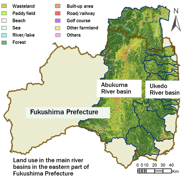
AIn the areas around Abukuma River and main river systems in Hamadori-District (east coast of Fukushima Prefecture), 70% of radioactive cesium is deposited in forests. The other radioactive cesium is deposited in mainly paddy fields and other farmlands.

Fig.1 Example for land use around main river systems in eastern Fukushima Prefecture
Table 1 Area and initial 137Cs deposition amount for main land uses
| Land Use | Area [ km2 (%) ] | Amount of initial 137Cs deposition [TBq (%)] | ||
|---|---|---|---|---|
| km2 | % | Bq | % | |
| Forest | 5,329 | 63.7 | 9.2×10¹⁴ | 70.8 |
| Paddy field | 1,157 | 13.8 | 1.6×10¹⁴ | 12.3 |
| Farmland | 852 | 10.2 | 1.3×10¹⁴ | 10.0 |
| Built-up are | 457 | 5.5 | 6.8×10¹³ | 5.2 |
| Others | 147 | 1.8 | 1.7×10¹³ | 1.3 |
| Wasteland | 152 | 1.8 | 1.6×10¹³ | 1.2 |
| River/Lake | 156 | 1.9 | 1.1×10¹³ | 0.8 |
| Road/Railway etc. | 67 | 0.8 | 1.0×10¹³ | 0.8 |
| Golf course | 47 | 0.6 | 3.5×10¹² | 0.3 |
| Beach | 1 | 0.01 | 1.9×10¹¹ | 0.01 |
| Total | 8,365 | ― | 1.3×10¹⁵ | ― |
Related articles
References
- 山口正秋, 前川恵輔, 竹内真司, 北村哲浩, 大西康夫(2013): 土砂移動に着目した福島第一原子力発電所事故後の放射性物質分布に関する解析手法の開発, バックエンド研究, vol. 20, no. 2, 53-69. https://doi.org/10.3327/jnuce.20.53
- Kitamura, A., Yamaguchi, M., Kurikami, H., Yui, M. and Onishi, Y. (2014): Predicting Sediment and Cesium-137 Discharge from Catchments in Eastern Fukushima, Anthropocene, vol. 5, 22-31. https://doi.org/10.1016/j.ancene.2014.07.001
