Radioactivity and Air Dose Rate
(2021)
QTell us about the machine learning that, I heard, accurately estimates air dose rates at 1 m above the ground level from measurements taken using an unmanned helicopter.
AJointly with Nagoya University, JAEA successfully developed a new radiation data analysis technique to swiftly and accurately generate radiation maps from big data obtained using an unmanned aerial vehicle (UAV). This was realized by utilizing machine learning, an application of artificial intelligence (AI).
This technique enabled us to create radiation maps reproducing ground-based survey values 30% more accurately than conventional methods. This also shortened the time required for the analysis, from over 1 hour to just several minutes.
It is anticipated that this new technique allows swift and accurate production of detailed radiation maps in the evacuation areas around the Fukushima Daiichi Nuclear Power Station (NPS), and provides scientific basis for the decontamination and lifting evacuation orders.
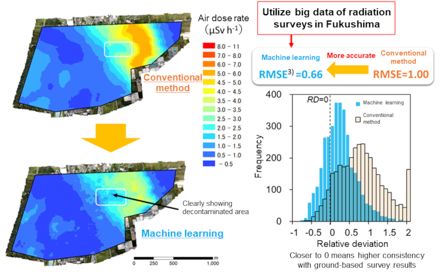
Fig. 1 Effects of machine learning
We devised a new radiation information analysis technique applying machine learning to easily evaluate the distribution and intensity of radiation sources that used to require piecing together various types of information in the past. This technique is based on data obtained by many environmental radiation surveys conducted in Fukushima.
Conventionally, when creating a radiation map using data obtained from radiation measurements from a distant location, researchers and engineers with special knowledge ran simulations to calculate the dose rates and radioactivity at the target site taking into account various factors including the nature of the radiation detector used, distance from the target site that is affected by the topographic features, and shielding by buildings (Fig. 2). Such techniques were labor intensive and not very realistic especially when dealing with a huge amount of environmental data. To address that, scientists came up with simplified conversion parameters derived using empirical or standard models to estimate the distribution of radiation sources and other vital information, but the accuracy of conversion has always been an issue.
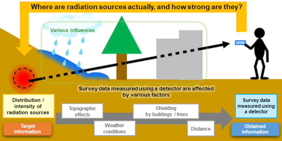
Fig. 2 Difficulty of estimating distribution of radiation in the environment
Since the accident at the Fukushima Daiichi NPS, many environmental monitoring surveys have been conducted to understand the distribution of radioactive materials and their changes with time. Especially, for their advantage of being able to cover a wide area, airborne UAV surveys have been utilized for understanding the dose rate distribution, combined with a mapping technology using a geographical information system. In the past, airborne radiation survey results were converted to ground-level radiation values by applying simplified parameters that were calculated from a comparison of airborne and ground-based survey values in a flat area with a constant dose rate distribution. This conversion technique is somewhat accurate, but has a major issue: errors become large in areas with complex topographic features or dose rate variations. About 10 years have passed since the accident at the Fukushima Daiichi NPS, but some sections are still designated as evacuation areas near the NPS. Swift and accurate production of detailed radiation maps in such areas is likely to provide scientific basis for the decontamination and lifting evacuation orders.
In order to resolve such an analytical issue in radiation surveys, JAEA has been working on the development of a new conversion technique for airborne survey data. Recently, we performed basic examination to realize simple yet highly accurate conversion with a machine learning algorithm that uses many data obtained in the past as the learning data. The examination was performed using commercially available machine learning software so that anybody can easily apply it, and the characteristics of learning parameters and the accuracy of conversion results were evaluated.
For the machine learning algorithm, we used commercially available machine learning software NeuralWorks Predict (made by NeuralWare, US). This software can be used as an extension of Microsoft Excel, allowing easy data handling. Using this software, we input count rates in which airborne gamma-ray spectra data we have obtained were sectioned by energy and information on the distance between the ground surface and the helicopter position, and built a neural network to output air dose rates on the ground (Fig. 3). In the machine learning using the neural network, the errors between output values and correct values were calculated and parameters of the neural network were adjusted to bring the output values closer to the correct values to build a neural network that allows optimal conversion. When a trained optimized neural network is applied to airborne survey data, the data are converted to air dose rates on the ground.
To find the neural network building conditions for highly accurate conversions, we evaluated the required number of training data (combinations of airborne and ground-based survey results) and the parameters (the number of layers) of the neural network. First, the number of training data in building a neural network was changed to examine the accuracy of conversion results associated with an increase in the number of training data. For the accuracy examination, the ground-based air dose rate survey values obtained in the same area of the UAV-survey data were set as the correct values, and the mean errors (RMSEs) between converted values and the correct values were used (Fig. 4). The training data shown in Fig. 4 were measured at a height of 50-60 m. TD1 and TD2 were constructed by machine learning using data with total radiation count rates of 0-5000 cps and 5000-10000 cps, respectively.
As a result, it was found that a certain level of accuracy can be obtained (Fig. 4, left: the RMSE values reach a plateau) when the number of training data is 200 or more (e.g., 200 training data with total count rates of 0-5000 cps measured at a height of 50-60 m).
Also, as a result of checking the change in the errors between converted and correct values by changing the number of layers for the neural network, it was found that a certain level of accuracy can be obtained (Fig. 4, right: the RMSE values reach a plateau) when the number of hidden layers is 10 or greater. Based on these examination results, we built a neural network to be applied to actual survey data.
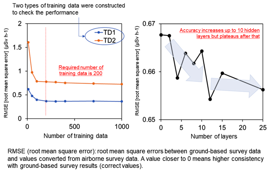
Fig. 3 Schematic illustration of artificial neural network training
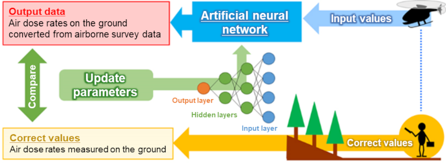
Fig. 4 Examination of required number of training data and relationship between number of layers and calculation accuracy
Using the neural network built by machine learning, we analyzed UAV-survey data obtained near the Fukushima Daiichi NPS and created a radiation map. Also, to compare, we created a radiation map generated by converting UAV-survey data using simplified parameters (i.e., conventional method). Fig. 1 shows the two radiation maps created. Fig. 1 tells us that the radiation map created using machine learning visualizes the distribution of dose rates in detail, compared to the radiation map created by the conventional method. To numerically examine the accuracy of the radiation map generated by applying machine learning, the converted values were compared with the data measured on the ground (correct values). As a result of calculating the errors (RMSEs) between the converted values and correct values, the result of conversion using machine learning was 0.66, an improvement by 34% compared to the conventional method (1.00). This result indicates less errors and overall improvement in the accuracy when machine learning is used, compared to the conventional method.
To check the accuracy, a histogram of relative deviations as defined by {[Airborne survey results]- [Ground-based survey results]/ [Ground-based survey results]} is shown on the right side of Fig. 1. A relative deviation value closer to 0 indicates higher consistency with ground-based survey results. While the conventional method shows relative deviations in a two-peak form, machine learning shows relative deviations in a distribution peaking around zero. As such, machine learning improved the accuracy in general, not just mean errors. These results demonstrate that the conversion technique using machine learning enables creating more accurate radiation distribution maps compared to the conventional method.
Further, while the conventional methods required about one hour to process radiation survey data for the same area, this technique completes calculation for the entire area in several minutes as long as a trained network is available. This calculation speed would even enable real-time data analysis in the future.
- Machine learning:
Machine learning is a process for a computer to learn based on a mathematical data model without receiving direct instructions from humans. Machine learning is regarded as a part of artificial intelligence. In machine learning, a computer recognizes patterns in data using algorithms and creates a data model for prediction using the patterns. - Deep learning:
A type of machine learning. All humans do is to configure basic parameters related to data, instead of organizing data and applying predefined formula. Once that is done, the computer learns on its own how to solve issues through recognition of patterns using multilayered processing. - RMSE (Root mean square error):
Root mean square error. Defined by. In this study, the ground-based survey values and values converted from airborne survey values were derived, and the mean errors were calculated. - Neural network:
It refers to a network, built by deep learning, of arrays binding basic elements that correspond to neurons. It is an attempt to elucidate the cranial nervous system of humans and to reproduce that utilizing the power of technology. A machine will be able to learn just like a human by changing the weight vector of each element.